Here is a Link to the 2014 Annual Meeting Minutes https://drive.google.com/file/d/0B4_qn55RcR-uUlB1QUZOVHI3U3M/view?usp=sharing
For prior years go to https://drive.google.com/folderview?id=0B4_qn55RcR-ucXU0djZRR1RnbGs&usp=sharing

Current news for the Hancock and Sand Ponds Association Go to our website for general information, maps, news letter, archived documents, environmental information and calendar events.
Wednesday, May 27, 2015
Sunday, May 24, 2015
Buoys Are In
Thanks to Andrew Clements and Crew for getting in the buoys in spite of the windy weather.


Friday, May 22, 2015
USGS Water Watch

WaterWatch (http://waterwatch.usgs.gov) is a U.S. Geological Survey (USGS) World Wide Web site that displays maps, graphs, and tables describing real-time, recent, and past streamflow conditions for the United States. The real-time information generally is updated on an hourly basis. WaterWatch provides streamgage-based maps that show the location of more than 3,000 long-term (30 years or more) USGS streamgages; use colors to represent streamflow conditions compared to historical streamflow; feature a point-and-click interface allowing users to retrieve graphs of stream stage (water elevation) and flow; and highlight locations where extreme hydrologic events, such as floods and droughts, are occurring.
The streamgage-based maps show streamflow conditions for real-time, average daily, and 7-day average streamflow. The real-time streamflow maps highlight flood and high flow conditions. The 7-day average streamflow maps highlight below-normal and drought conditions.
WaterWatch also provides hydrologic unit code (HUC) maps. HUC-based maps are derived from the streamgage-based maps and illustrate streamflow conditions in hydrologic regions. These maps show average streamflow conditions for 1-, 7-, 14-, and 28-day periods, and for monthly average streamflow; highlight regions of low flow or hydrologic drought; and provide historical runoff and streamflow conditions beginning in 1901.
WaterWatch summarizes streamflow conditions in a region (state or hydrologic unit) in terms of the long-term typical condition at streamgages in the region. Summary tables are provided along with time-series plots that depict variations through time. WaterWatch also includes tables of current streamflow information and locations of flooding.
Wednesday, May 20, 2015
Lower Spring Water Level Not Refelective of Policy Change
The plan for this Spring was to maintain past water levels. The transition from the previous dam manager to an interim manager left a void. I was not able to get to the dam myself in a timely fashion. Dry weather has not helped.
The dam gate was not "closed" soon enough to support past Spring water levels. "Closed" means the gate must be left open at least a few inches for downstream flow.
Current conditions are not related to the Water Level Committee. Any recommendations from the committee are future oriented and must be approved by members at the annual meeting.
Jerry Holt
HSPAMaine@gmail.com
USGS Water Watch Click here for info regarding water flows and drought conditions.
USGS Water Watch Click here for info regarding water flows and drought conditions.
Monday, May 18, 2015
Dry Winter and Spring
In spite of all the snow we had this winter the water content was approximately half of a normal winter. This spring also has been dry with below normal rainfall. "Most areas need 2-6 inches of rain to elevate the current drought conditions."
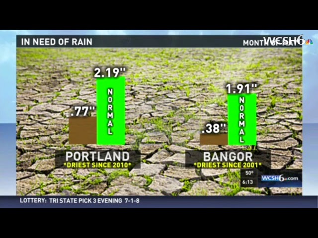
Check out this article from the Portland Press Herald.
The graphic below is from Monday May 18th morning weather report. This only refers to rainfall deficit for the first 18 days of May.
Wednesday, May 13, 2015
Retirements
Retirements
Ed Cooper has retired from managing the dam on Hancock Pond. Ed is one of the "originals' on the pond and has given many years of service to HSPA.
Chris Gouterman is retiring from our milfoil/boat inspection program and has diligently kept us up to date regarding these issues.
Both Ed and Chris have volunteered great time and effort, often behind the scenes, to make Hancock and Sand Ponds a better place to enjoy.
Thank You
Subscribe to:
Posts (Atom)